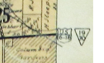
| To learn what the numbers on the symbols near modern Blue Mound Road mean, I contacted Emlynn Grisar, Wisconsin Department of Transportation southeast regional communications manager. She posed the question to Tom Heydel, WisDOT traffic operations engineer, and he sent a link to a website (http://www.wisconsinhighways.org/listings/WiscHwys 10-19.html#US-018) that includes the following: "Soon after its creation, US-18 was rerouted between downtown Waukesha and downtown Milwaukee generally via its present-day route including Bluemound Rd and Wisconsin Ave. At this point, the route between Goerke's Corners and downtown Milwaukee was signed as US-16/US-18/STH-19/STH-30! By 1931, though, US-16 had been relocated to Capitol Dr, leaving just US-18/STH-19/STH-30. Meanwhile in 1932, US-18 was relocated onto its present-day route between US-12 at Cambridge and Jefferson in Jefferson Co." |